Netherlands Canals and Polders
Mar. 16th, 2021 08:24 pmI put this on Facebook a few hours ago. Since I did, 7 people have "wow" reacted which is a lot more interest than I usually get on posts! I hope that means people found it surprising and interesting!
---
The Netherlands is synonymous with canals, but I didn't have a good understanding of how and why before I started reading as I planned my move.

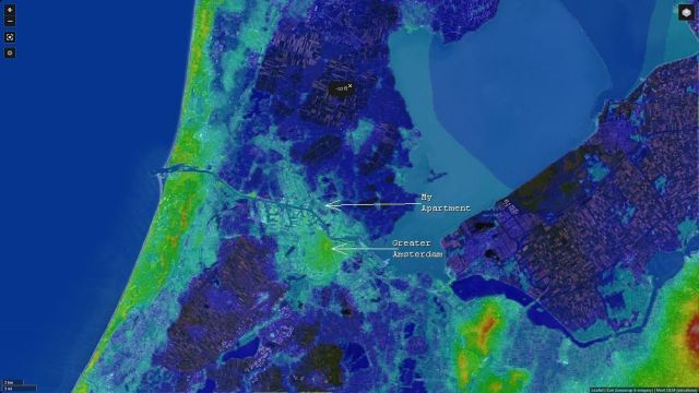
Here's an elevation map of the area around Amsterdam. Greater Amsterdam itself is mostly above sea level, but notice the huge swaths of darker blue representing land below sea level. That was basically all part of the ocean bay called the Zuiderzee (southern sea) before the Dutch decided they needed more places to grow things.
Engineers isolated large chunks of ocean by surrounding them with earthen dikes. Once that was done, they set up pumping stations, traditionally windmills since this began as early as 1533. Many of the classic Dutch windmills weren't milling grain: they were pumping water. Running through the mid-20th century, the later projects dried areas as large as 40,000 to 50,000 hectares (apx. 100,000 to 123,000 acres). The dewatering could take a year or more. Once it was done, the already low-lying ocean bottom dried out and compressed down, lowering the elevation further. The area of new land is called a polder.
As you see in this image, a great portion of the northwestern Netherlands is comprised of these polders. The reason canals seem to be *everywhere* is that the polders must have constant drainage toward a pumping station that lifts the collected water up to sea level to be returned to the North Sea: otherwise, they would all gradually flood up to ocean level again. In fact, during World War II, Nazi sabotage and attacks flooded some of the polders.
It's like the basement of a building. Often there's a sump to collect groundwater that would otherwise start filling the basement, and a pump to discharge it at ground level. Except on a rather larger scale.
---
The Netherlands is synonymous with canals, but I didn't have a good understanding of how and why before I started reading as I planned my move.

Here's an elevation map of the area around Amsterdam. Greater Amsterdam itself is mostly above sea level, but notice the huge swaths of darker blue representing land below sea level. That was basically all part of the ocean bay called the Zuiderzee (southern sea) before the Dutch decided they needed more places to grow things.
Engineers isolated large chunks of ocean by surrounding them with earthen dikes. Once that was done, they set up pumping stations, traditionally windmills since this began as early as 1533. Many of the classic Dutch windmills weren't milling grain: they were pumping water. Running through the mid-20th century, the later projects dried areas as large as 40,000 to 50,000 hectares (apx. 100,000 to 123,000 acres). The dewatering could take a year or more. Once it was done, the already low-lying ocean bottom dried out and compressed down, lowering the elevation further. The area of new land is called a polder.
As you see in this image, a great portion of the northwestern Netherlands is comprised of these polders. The reason canals seem to be *everywhere* is that the polders must have constant drainage toward a pumping station that lifts the collected water up to sea level to be returned to the North Sea: otherwise, they would all gradually flood up to ocean level again. In fact, during World War II, Nazi sabotage and attacks flooded some of the polders.
It's like the basement of a building. Often there's a sump to collect groundwater that would otherwise start filling the basement, and a pump to discharge it at ground level. Except on a rather larger scale.